


Despite having been stripped of their voting power by the City Council, four members of the Planning Commission and an alternate gave the equivalent of a no-confidence no-vote Monday night to a 20-acre rezoning request.
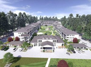
The proposal by property owner Mike Hyde included a first-phase $80 million construction of 308 apartments and a 2-acre central park on a portion of a 20-acre site in south Peachtree City. Later phases would bring an upscale restaurant, some mixed-use retail residential and possible commercial and office units.
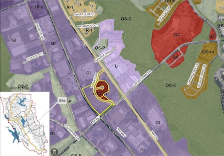
The site is at the northwest corner of the intersection of Ga. Highway 74 South and TDK Boulevard behind the Pit Stop Convenience Store. It’s adjacent to an as-yet unbuilt hotel approved 5-to-0 by the council 2 years ago after a 5-to-0 disapproval by the Planning Commission.
The Feb. 22 meeting had some tense moments as Chairman Michael Link navigated through a new hearing process mandated by the City Council, including the loss of the commission’s power to vote on a proposal.
The volunteer commission has voted on every rezoning request for more than 40 years. The vote has been a formal recommendation either in favor of a rezoning or in opposition to a change. In every case, the City Council had final say on any rezoning.
Formal public hearings are now out, replaced by a council-mandated “public workshop” format, which saw new 3-minute time limits imposed on all citizens’ public responses but provided no time limits on the developer who requested the zoning change.
This feature drew criticism from one member of the audience, former Mayor Steve Brown. Brown and Chairman Link sparred over the new process, especially the strict time limit, leading Link to admonish Brown to yield the microphone and sit down. Members of the public present who were not parties to the rezoning request or city staff numbered fewer than a half-dozen.

Brown and a majority of the commission said they were concerned about the nearness of the 3-story apartment buildings to the CSX rail line bordering the rear of the 20-acre site, including a parallel rail spur used as a parking lot for rail tank cars, many loaded with hazardous liquids.
Brown brought up the specter of a derailment or a leaking tank car and its effect on hundreds of apartment residents living little more than 100 feet from the escaping noxious vapors.
Another first: City Manager Jon Rorie walked to the microphone and said he was speaking as a private citizen, something he had not done since arriving in Peachtree City.
He said it’s a mistake to think that if a community provides appropriate residential areas that commercial development will follow, providing jobs and tax income. “Commercial doesn’t follow residential,” Rorie said.

In addition, Rorie said, “I don’t think that’s a proper location for mixed-used” development, mainly due to its current designation as and proximity to an industrial zone.
The project plan calls for upwards of 10,000 square feet of “retail/leasing and amenity space” much of which would be the ground floor of two of the eight apartment buildings in the first phase. Space would be left for future development of a restaurant and a “commercial pad.” The plan also calls for 780 parking spaces.
In brief, 308 apartments would come first and everything else later.

Commissioner Scott Ritenour said he had concerns about the relative lack of retail space in what is billed as a mixed-use project. “We have enough coffee shops in Peachtree City now,” he said. He also didn’t like the one-way-in, one-way-out design.
Alternate member Rick Mendenhall said he was concerned about the 89 students projected being added to the Starr’s Mill school complex by the apartments. He said he was against mixed-use projects, but “my vote doesn’t count.”

Commissioner Frank Destadio criticized the lack of detail in the rezoning proposal, including details about building size. He said the proposal lacked provision for adequate golf cart parking. He said even though the commission was prohibited from an official vote, his unofficial vote would be no.
Vice Chairman Paul Gresham said the plan lacked an overall vision that would create a sense of place. The eight apartment buildings were “just a bunch of boxes that don’t relate to each other very well.”

Chairman Link said the submitted proposal failed to contain enough details about the buildings that were close to the rail tracks. Nearby truck traffic also was a concern, Link said.
Project builder Woodfield Development was represented by Patrick Kassin, who explained that the company specialized in developing rental properties.
He said the apartments were luxury units that would start around $1,500 a month for one-bedroom studio apartments. He described his company’s screening process for tenants who would sign yearly contracts.
He said the complex would contain 308 units: 114 1-bedroom units, 160 2-bedroom units and 34 3-bedroom units.
At an 80% occupancy rate, the apartments would yield a minimum of $4.4 million a year to the company.
City staff said although the rezoning application did not contain the detail in writing, they thought the buildings were 3-story.
Below is the written summary of the requested rezoning to Limited Use Commercial compiled by the city planning staff:
FROM: Robin Bechtel Cailloux, AICP
Director Planning & Development
DATE: February 19, 2021
SUBJECT: Rezoning of 20 Acres, Widget Drive from General Industrial (GI) and LUC-31 to Limited Use Commercial (LUC).
February 22, 2021 Planning Commission Meeting
Request
Nathan Dockery, the Applicant, is requesting the rezoning of about 20 acres from GI General Industrial and LUC-31 to Limited Use Commercial (LUC) for a mixed use development to include multi-family up to 16 units per acre, commercial, hotel, and greenspace uses.
Location
The subject property is located on Widget Drive south of the Avery Dennison complex, north of TDK Boulevard, east of the CSX railroad right-of-way, and behind the Pitt Stop fueling station complex.
Widget Drive is a private drive, and the access point where Widget Drive intersect State Route (SR) 74 south is the only road frontage of this property on SR 74. The small pond located along SR 74 is owned by Avery Dennison. Figure 1 shows the outline of the property seeking the rezoning.
A portion of the property was rezoned for an extended-stay hotel in 2019. Although the hotel property is part of the overall design of the master plan, the location of the hotel is not being changed as a part of this request.
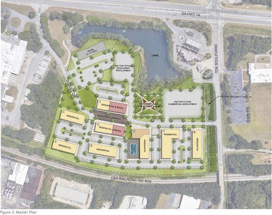
Proposed Master Plan and Area Improvements
The proposed master plan (Figure 2) is centered along a re-aligned Widget Drive, with ground-level retail and residential facing the main street. The hotel remains in the northern corner, and a restaurant pad is located next to the hotel overlooking the lake.
Moving further south, a mixed-use residential/ground-level retail building faces the central main street. A lakefront lawn and public event site (about half the size of the Drake Field lawn) is centrally located along the main street between the mixed-use residential building and a future commercial pad site.
Residential is located on the southwestern side of the main street. A mixed-use residential building with ground-level retail is located near the main amenity building, which is located directly across the main street from the lakefront lawn. A 50-foot setback along the railroad is maintained for all residential buildings.
Internal circulation for vehicles is provided mostly by parking lots connected to the central main street. The applicant is requesting to partner with the City in proposing a special-purpose traffic signal at Widget Drive and SR 74 to allow protected left turns for trucks leaving Avery Dennison. The light would only be activated by heavy trucks leaving Avery Dennison and would otherwise remain green for vehicles traveling SR 74.
The applicant has committed to doing the studies required by GDOT for this signal, and installing the necessary improvements at the intersection.
In addition, the applicant is proposing to partner with Avery Dennison to provide the land at no cost to the city for a path tunnel under SR 74 at this intersection. The proposed tunnel would connect to the existing path network located at the City Police station along the service road in front of Rip-Tide.
In addition, the applicant has committed to purchasing wetland credits to cross the Flat Creek tributary behind McDonald’s in order to complete a path connection from the Police Station to McDonald’s and the new paths along Crosstown Drive. See Figure 3 for a map of the existing path network and the location of proposed improvements and contributions.
City Policies and Goals to Consider
Beyond the design of the proposed master plan, an evaluation of the proposal against adopted city-wide policies and goals is summarized below.
Comprehensive Plan Goals
The Future Land Use Map, which is a part of the Comprehensive Plan adopted in 2017, designates the property, including the approved hotel site, for industrial use.
Staff has identified several Comprehensive Plan goals applicable to the proposal:
•Protect environmentally sensitive land and enhance the City’s greenbelts and open space areas
•Staff comment: The master plan preserves the required setbacks from the lake, which is the only environmentally sensitive land on the site.
•Develop and redevelop land based on the village concept
•Staff comment: The site is within the Braelinn village center, which extends along Crosstown Drive from the Kmart shopping center to the existing fast-food and gas station sites at the intersection with SR 74. Proposing multi-family within and adjacent to a village center meets the Comprehensive Plan’s definition of the village concept.
•Promote the location of industrial uses in the industrial park, commercial uses in the village centers, and step-down residential densities the further they are from village centers
Staff comment: This property was originally part of the city’s industrial park. Changing the land use from future industrial to mixed-use does not meet the standard of locating industrial within the industrial park.
However, the location of the gas station and restaurants (commercial), and the changing of industrial land for a hotel (commercial) makes the location of future industrial users difficult at this site.
•Staff comment:The location of higher-density housing adjacent to the Braelinn village center is meeting the step-down standard.
•Discourage any “strip-type” commercial development
•Staff comment: The proposed commercial is integrated into the development both as stand-alone sites and ground-level mixed-use sites, thereby meeting this standard.
•Encourage development of high-quality local jobs suitable for city residents
•Staff comment: Changing the site from industrial may make a case for how this proposal does not meet this goal. However, not all industrial jobs are higher-paying. The post-pandemic economy will likely result in fewer concentrations of office buildings as many businesses adjust to remote-working schedules.
•Work towards reducing the property tax burden on residents
•Staff Comment: In order to reduce the residential portion of the city’s property tax revenue without reducing services, the non-residential portion must increase. This can be done either by annexing new commercial properties or by increasing land values for existing commercial properties. To increase commercial property values, the property owner must invest in their property. Like all property owners, they must see an increased financial return on that investment.
The applicant is proposing to invest $80-100 million into a property that is currently undeveloped property.
•Encourage alternative modes by providing a comprehensive system of multi-use paths and facilities
•Staff comment: the site will provide internal sidewalks and path connections. The applicant has also committed to improving the path network connectivity in three areas: across SR 74 from Widget Drive to the Police Station path, across the Flat Creek tributary behind McDonald’s to the new connections on Crosstown Drive, and future path connections along TDK.
They are proposing to partner with the City and Avery Dennison to construct a tunnel under SR 74 to connect to the path at the City Police Station along the Rip-Tide service road. They have contacted the McDonalds’ property owner and verified that they would agree to a path connection at their rear property line across the Flat Creek tributary, and they commit to purchasing wetland credits for the crossing if they are necessary.
And finally, they have preserved a 60-foot buffer along TDK Boulevard for long-range future path connection over the railroad bridge.
•Provide a broad range of housing opportunities with an appropriate mix of homes regarding size, type, price, and location in order to meet the needs of people of all life stages and abilities.
•Staff comment: the proposal would provide new multi-family housing to the City. Of the over 13,000 housing units in the city today, about 10% are multi-family. The applicant has proposed rental rates starting at about $1,500 a month, which would require a family or individual to earn about $67,000 a year to qualify to rent the smallest unit.
•Offset dense residential developments with greenbelts and parks.
•Staff comment: The master plan shows a 1.3 acre central park, and about 3.6 acres of greenspace and buffers. This is about 24% of the total area and nearly meets the Council’s standards for 25% greenspace in new developments.
•Continually provide adequate levels of service in all areas as needed for the residents of Peachtree City.
•Staff comment: The applicant has provided a traffic study of the surrounding intersections up to the Crosstown Drive/ Peachtree Parkway intersection. The analysis indicates that the project reduces the level of service for the intersection of SR 74 and TDK.
The recommendation from the study is to re-stripe the southbound left turning lane to create dual lefts. The City Engineer comments that the applicant should be financially responsible for the necessary improvements at this intersection to maintain the level of service.
•Staff Comment: Based on the student generation data from the Fayette County Board of Education, the estimated number of school-age children generated by the project would be 89 children, of which 44 would be elementary age, 26 would be middle school age, and 19 would be high school age. This property is served by the Starr ’s Mill feeder system, which consists of Oak Grove Elementary, Rising Starr Middle, and Starr’s Mill High.
•Staff Comment: Water and sewer would be provided by the Fayette Department of Water and the Peachtree City Water and Sewerage Authority, respectively. The applicant has provided letters from each utility stating that there is capacity for the project. It’ s worth noting that adding rate payers to the sewer system spreads the capital bond payments across more users, and has the potential to reduce rates for all users.
Council-adopted Policies
Council has adopted a policy of no more than 75% of land being dedicated to residential uses in mixed-use developments. 63% of the land is dedicated to residential and mixed-use residential. The remaining 37% is dedicated to commercial uses. This satisfies the Council’s land use policy.
Council has adopted a policy of requiring 25% open space in new developments. The proposal includes about 4.9 acres of parks and open space, which is 24% of the total area.
Annual Council Priorities: Path Network Connection over SR 74
The 2017 voter-passed Special Purpose Local Option Sales Tax (SPLOST) included a project to conduct an engineering feasibility study to locate the most feasible crossing somewhere between the existing connections under SR 74 at Paschall Drive in the north and Rockaway Road in the south. See Figure 4 for a map of the existing path crossings and the general location for the SPLOST study.
The applicant has hired the engineering firm Kimley-Horn to conduct a feasibility study of the path crossing in the vicinity of their proposed project, and determined that the most feasible location in the immediate area would be at the proposed special purpose traffic signal at SR 74 and Widget Drive. Avery Dennison has agreed to donating the property for the tunnel landing if the traffic signal is approved. The rough cost estimate of the tunnel is about $800,000 without including the cost of land and easements.
Annual Council Priorities: Community Improvement Districts (CID)
In 2019, the Council requested that staff evaluate the creation of a Community Improvement District (CID), a power that the State granted the City in 2018. A CID is a defined geographical area where the commercial property owners agree to tax themselves more than their current rate. The additional money generated from this tax can be used to make improvements within the District, such as transportation, landscape, or facade improvements, to name a few.
Staff created initial CID boundary maps to identify where a CID would be appropriate, including the Braelinn Village Center. Figure 5 shows staff’s original assumption for the Braelinn Village CID boundaries. Given the commercial nature of the Pitt Station, the CID boundaries extended from the Kmart shopping center to this property across SR 74. The applicant is committing to assist with the creation of the Braelinn Village CID, and has already contacted the majority of commercial property owners in the area.
The applicant has committed to provide an expert consultant to partner with the City in order to establish the Braelinn Village CID. If the CID is created, revenue generated could be used to extend City funds already earmarked for transportation improvements in the area such as the intersection of Peachtree Parkway and Crosstown Road and future path projects.
Potential Areas for Improvement
The proposal meets many of the City’s Comprehensive goals and policies, as well as Council priorities summarized above. To spur discussion during the workshop, staff has identified a handful of areas that could be improved in the project.
First, the restaurant site is clearly located to provide the best view of the pond to the patrons. However, if is a bit disconnected from the rest of the development. The street serving the restaurant passes the mixed use residential building 1 and then an open parking lot. Staff would like to see building 1 be shaped like an “L” to further line the restaurant street and hide the parking lot.
Staff would also like to see a sidewalk along the side of the road, and better inter-parcel connection between the restaurant parking lot and the hotel parking lot. In addition, where angled parking is located, wider adjacent sidewalks (at least 10 feet wide) should be provided to offer pedestrian refuge and a better sight line to adjacent buildings.
Architectural detailing is essential in mixed-use developments. Not enough details, and the buildings appear flat, cheap and out of scale. Therefore, staff would like to make sure that if the property is rezoned, these buildings return to the Planning Commission for architectural review. In particular, residential-only buildings facing Widget Drive should be broken up vertically to create dimension and visual interest. Consideration for street-level entrances for these units, giving a similar appearance to brownstones, is encouraged by staff.
Workshop Format
During the workshop, staff will provide a general overview of the proposal. The applicant will then be able to present their project. Then the Chairman will open up discussion to the general public asking for comments, suggestions, and questions. Afterward, the Chair will ask the applicant or staff to respond to the questions, and allow the Commissioners to make their comments. A summary of these comments will be provided to City Council for their review prior to the public hearing, which will be held on March 4, 2021 at 6:30 pm in City Hall.
APPLICANT NARRATIVE
WRITTEN NARRATIVE PEACHTREE CITY REZONING APPLICATION
•Whether the zoning proposal is in conformity with the policy and intent of the land use plan;
•Land Use:
The applicant proposes to develop an approximate 20.5 acre parcel located on the southwest corner of GA Highway 74 and TDK Boulevard in Peachtree City. The property is located adjacent to Avery Dennison Corporation and TDK Boulevard.
The applicant proposes to build a master planned community consisting of a mix of residential uses, a commercial building, a lakefront restaurant, retail and community open space as well as other community amenities such as a pool and a gym.
The maximum number of proposed residential dwelling units would be 16 units per gross acre.
To facilitate the proposed development, the applicant requests that the property be rezoned from General Industrial (GI) to Limited Use Commercial (LUC) to allow for the mix of residential, retail, restaurant, commercial and community amenity uses.
The proposed development will be phased as follows: Phase I will include the residential dwelling units and podium retail. Phase II will include the commercial, and remaining retail/restaurant parcels.
Though the 2017 Comprehensive Plan currently designates the site area as “Industrial” and within the Industrial Park, the proposed residential development would be in conformity with the policy and intent of the comprehensive plan.
The comprehensive plan states in its housing policies the goal to “create a sense of neighborhood by developing separate and identifiable subdivisions surrounded by open spaces and appropriate landscape buffers” and to “provide a broad range of housing opportunities with an appropriate mix of homes regarding size, type, price and location in order to meet the needs of people of all life stages and abilities.”
In addition, in a summary of citizens’ opinions and concerns, the comprehensive plan states that citizens of Peachtree City appreciate sense of community, abundance of greenspace and recreational opportunities in Peachtree City. However, they are concerned by the limited housing type options.
The proposed development would create a lake front community that would provide housing types and that will serve the needs of people of a range of needs and abilities in the City.
•Community Design:
The proposed development would create a community design consistent with the village concept.
The 2017 comprehensive plan acknowledges that the definition of the village concept is currently unclear. The plan states a goal to define the village concept, but does not explicitly outline a definition.
However, historically, the village concept in Peachtree City has meant places where one could live, play, shop and possibly work.
The proposed development will create a mixed-use residential community adjacent to a lake that will contain a vibrant mix of amenities and opportunities for living, working and recreation.
Further, though the development is located within the Industrial Park, it is more compatible with the development immediately to the east, which contains a residential subdivision, a shopping district and is also adjacent to the Industrial Park to the east and south.
The proposed development would provide multi-use path connections between residential and commercial properties and community facilities, such as retail shops, restaurants, social center and multifamily buildings.
The proposed development would preserve natural resources on the site by limiting the developed area leaving open space areas as well as preserve specimen trees and vegetation along roadways or boundaries by providing sufficient area between the proposed buildings and drives aisle to the existing roadways and boundaries.
Further, the development would incorporate natural storm water management designs such as the utilization of ponds. The development will be providing various open space areas and the building architecture, signs, landscaping, lighting and other urban design elements would articulate the village concept. The community design will encourage multiple modes of alternative transportation, including biking, walking and golf carts.
•Economic Development:
The proposed development will provide new retail/restaurant opportunities for existing or new county businesses. Phase I of the proposed development will be at cost of approximately $80 million dollars.
At the current millage rate Phase I of the proposed development will add an estimated $205,000 to the city’s tax base. The proposed development will also contribute approximately $1.35 million dollars in impact fees to the city. This does not include the additional future revenue and taxes from businesses operating in the retail, commercial and office spaces.
As part of the commitment to the community and the future quality preservation of values we will continue to work with the City to form a CID from the proposed development to the opposite end of Crosstown Drive. This would include the Braelinn Village Shopping Center and would promote quality growth in a private public partnership.
According to the Council for Quality Growth, “Community Improvement Districts (CIDs) have emerged as significant centers of influence in the Metro Atlanta region. By utilizing self-imposed tax revenues from commercial businesses within their districts they are dramatically changing their communities in many ways. From bold new infrastructure improvements to traffic mitigation, private security and the transformation of commercial streets into pedestrian friendly corridors to the creation of new parks, trails and greenspace, CIDs are enhancing the urban and suburban landscape. They have improved the standard of living throughout the region and will continue to do so at a rapid pace, as evidenced in recent history (Council, 2014).”
•Fire and Rescue:
The proposed development will add residential units combined with 15,000 sf of retail/leasing & amenity space, a restaurant space consisting of 5,500 sf and a commercial building consisting of 42,000 sf. See Section G below for explanation of Level of Service in the existing condition scenario vs build out scenario for the project. Sprinklers will be provided within the proposed buildings as required. The development will be compliant with NFPA 13R and NFPA 13 requirements and be protected by an automated Fire Alarm system. The proposed development is located 1.43 miles from Fire Station #81 and 1.33 miles from Fire Station #83. Existing roadway infrastructure provides clear Fire Department access to the entire proposed development. Additional Fire Hydrants will be constructed as required to serve the development.
•Potable Water:
Potable water is available to the site via an existing publicly maintained 8” water main located in Widget Drive. This line will be relocated and utilized for this development. This main is adequate to serve the project by itself and would be the likely service connection for the project.
•Sewer:
Sanitary sewer service is available via an 8” gravity line that is located within Widget Drive. This line is owned and maintained by the Peachtree City Water and Sewage Authority. The existing 8” sewer main has the necessary capacity available for the proposed mixed-use development.
•Transportation:
Several existing intersections serving the proposed development do not currently meet level of service (LOS) “D” based on background conditions (without the development). Three (3) intersections could be improved to achieve a level of service (LOS) “D” or better for their background conditions. The intersection of SR 74 and Widget Drive could be improved with a signal (if warranted). The intersection of SR 74 and TDK Boulevard/Crosstown Drive could be improved by adding an additional southbound left-turn lane (creating dual left-turns) through restriping. The intersection of Crosstown Drive and South Peachtree Parkway could be improved with a two lane roundabout. These improvements would bring the intersections to a level of service (LOS) “D” or better during the build-out of the proposed development. The proposed development will provide multi-use path and sidewalk connectivity within portions the site as well as to adjacent properties. Internal roads will also provide connectivity with the proposed site and to adjacent properties.
•Whether the zoning proposal will permit a use that is suitable in view of the use and development of adjacent and nearby property;
The proposed zoning proposal will permit a use that is suitable in view of the use and development of adjacent and nearby property. About a mile to the east of the property is single family housing along with shopping districts. To the north and south of the property are several light industrial properties. Just to the west is undeveloped land along with the Planterra Ridge Golf Club. The proposed mixed-use development would be complementary to the nearby golf course, residential, and light industrial uses and would add a mixture of more vibrant, community-oriented uses to the area.
•Whether the zoning proposal will adversely affect the existing use or usability of adjacent or nearby property;
The zoning proposal will not adversely affect the immediately adjacent property which is primarily light industrial uses. The proposed development will also not adversely affect the use or usability of nearby property. In fact, the proposed development will provide amenities for the surrounding uses that should make those properties more attractive.
•Whether the property to be affected by the zoning proposal has a reasonable economic use as currently zoned;
The lack of development on the property suggests the property does not have a reasonable economic use as currently zoned. The property’s location with access to Highway 74 makes it suitable for residential, office and restaurant uses.
•Whether the zoning proposal will result in a use which will or could cause an excessive or burdensome use of existing streets, transportation facilities, utilities, or schools; and
The zoning proposal will not result in a use which will or could cause an excessive or burdensome use of existing streets, transportation facilities, utilities or schools.
The current GI zoning allows many uses that have a significant impact on streets, transportation facilities and utilities such as office, manufacturing and assembly facilities, recovered materials processing facilities and distribution facilities.
Due to the mixed-use nature of the development with residential uses, the impact on streets, transportation facilities and utilities is not expected to be over burdensome and it is anticipated to be less impactful than development under the current GI district regulations.
The development will have some impact on schools because the change in zoning will result in the construction of residential units. Notwithstanding the foregoing, the impact is not expected to be excessive or burdensome because Oak Grove Elementary, Rising Star Middle School and Starrs Mill High School is anticipated to have adequate capacity at build out of the project.
Based on the traffic report prepared by Kimley Horn in January 2021 the proposed development will not negatively affect the traffic in the surrounding area. The report analyzed three scenarios of Estimated 2020 traffic Conditions, Projected 2024 No-Build Traffic Conditions and Projected 2024 Build Traffic Conditions. The intersection at TDK and Joel Cowan Parkway (SR74) is projected to operate a Level of Service E (Scale of A to F, A being best and F being worst) for both No-Build and Build scenarios at peak hours. The intersection will continue to operate at an acceptable LOS with the report recommended dual south-bound left turn lanes.
•Whether there are other existing or changing conditions affecting the use and development of the property which give supportive grounds for either approval or disapproval of the zoning proposal.
The fact that it has not been developed suggests that it is better suited for the mix of uses proposed by this application. Further, the Owner has marketed this land for sale for over 10 years at a consistent market price with surrounding properties and has not been able to sell the land under its current use. Several other properties having the same industrial use have sold in that time period in the area. The Mixed Use concept is supported in the recent LCI study completed by the city.


Leave a Comment
You must be logged in to post a comment.