


The Tyrone Town Council last week voted 3-1 to rezone a 55.8-acre portion of a much larger tract that had been annexed into the town in 1992. The annexation came with the understanding that the entire 479-acre property would be zoned M-2 (Heavy Manufacturing). A clerical error several years ago was said to be responsible for the 55-acre portion of the property being color-coded incorrectly on the town’s Land Use Map, hence the need for rezoning. A number of Southampton subdivision residents opposed the rezoning.
Research by town staff found that meeting minutes recorded in 1992 show that the Town Council accepted the entire 479-acre annexation, stating that it would accept the property with its M-2 zoning from Fayette County. The council in 1992 further noted that it would impose its own zoning on the property during the next planning process, ostensibly to occur in the timeframe of the mid-1990s. But that the action was never taken.
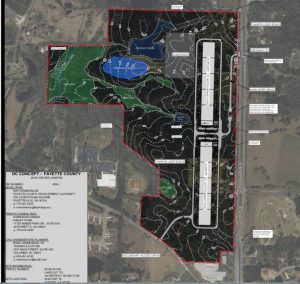
The error and the issue went without notice until representatives of the Hobgood family several months ago approached the town about a potential future development on the portion of the 55-acre property along Hwy. 74 that, unlike the asphalt plant immediately to the west and also positioned adjacent to Southampton, is not under a 30-year lease. That discussion led to the realization that the town’s zoning map shows the 55-acre property color-coded green (for A-R) while the Future Land Use Map in the 20-year Comprehensive Plan from 2007 shows it as purple (for M-2).
Aside from that discrepancy, the review of town records showed that the property never underwent the public process to officially establish the zoning for the 479-acre property or any portion of it, said town attorney Dennis Davenport. Nor did the Hobgood family ever request any change in zoning from the county’s M-2 category, either when the property was annexed or subsequent to that time. Meantime, the property had been taxed on the basis of M-2 zoning since being annexed in 1992.
A check with town hall confirmed that all meeting minutes from the planning commission and town council are accounted for.
Davenport at a previous meeting said the town investigated the situation over a period of 45-60 days after meeting with Hobgood representatives and could find no explanation for the error.
Davenport said the town found no record of how the 55-acre portion of the property came to be color-coded green (signifying A-R zoning) on the zoning map instead of being coded purple (designating M-2), as was the case with the remainder of the 479-acre property.
A number of Southampton subdivision residents had attended one or more previous meetings to voice their opposition to the rezoning request, saying that the current zoning as indicated on the zoning map should be retained. Yet the majority of the portion of the 55-acre property adjacent to Southampton is home to the asphalt plant that would require M-2 zoning.
Aside from the longstanding asphalt plant situated in the 55-acre area, a rock quarry, also operating prior to the annexation, is located on another portion of the property and immediately to the north of a large portion of Southampton.
Similar to the recent Planning Commission meeting, several Southampton residents said they had productive meetings with Hobgood representatives but, nonetheless, wanted the property to keep the A-R zoning indicated on the Land Use Map.
The vote by the council was 3-1, with Councilman Ken Matthews voting in opposition.


Leave a Comment
You must be logged in to post a comment.