


Study looks at impact of building a ‘city center’; some median cuts may be closed, left turns may be eliminated —
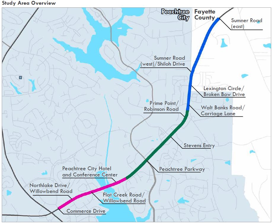
Peachtree City officials are looking to implement parts of a study detailing a major makeover of the City Hall area and significant traffic changes in the Ga. Highway 54 corridor from its intersection with Ga. Highway 74 eastward to the new city limits line.
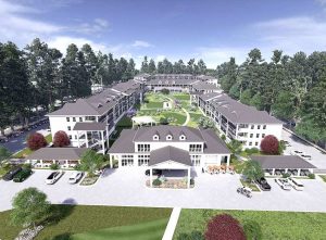
Maybe the largest impact that appears in the Pond and Associates study is the city’s push to plan and encourage creation of a new “city center” in the area around City Hall.
The study says of the “City Hall area redevelopment”:
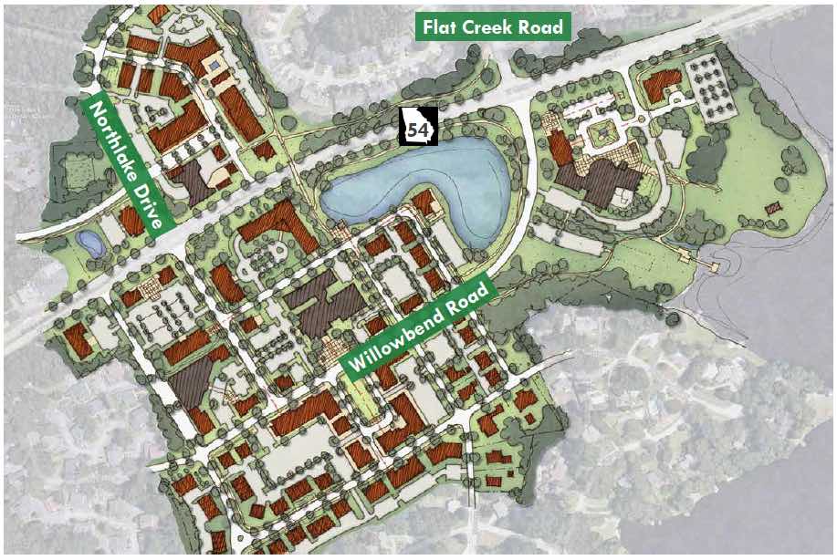
“Along [Ga. Highway] 54, a redevelopment is planned to bring a substantial increase in activity to the portion of SR 54 near its intersections with Willowbend Road, Northlake Drive, and Flat Creek Road. This site sits immediately west of Lake Peachtree, and includes Peachtree City’s City Hall and library.
“This mixed-use development is currently expected to include substantial retail and office components, mixed with single family homes, townhomes, and apartments, while preserving the existing municipal complex.
“An examination of this development was undertaken to anticipate the traffic impacts it will have on the roadway network and to identify specific improvements that can be made to mitigate these impacts and improve overall circulation throughout. … The redevelopment is expected to primarily impact the intersections of SR 54 with Northlake Drive/Willowbend Road and Flat Creek Road/Willowbend Road,” shown below.
A Feb. 25 Planning Commission workshop proposal to replace the current Aberdeen Center commercial area bordered by Hwy. 54 and Northlake Drive received little positive feedback from the commissioners.
Whether that proposed Aberdeen redevelopment is still on the front burner or even viable has not been announced, but there have been no further public meetings on the issue.
The December 2018 study’s description of the redevelopment area appeared to be based on that now dormant proposal. How the apparent collapse of that plan impacts the city center push remains to be seen.
Among the possible traffic enhancements considered for the Westpark area were two proposed new roads joining Westpark Drive with Aberdeen Parkway (the “northern option”) and with Northlake Drive (“the southern option”), shown below.
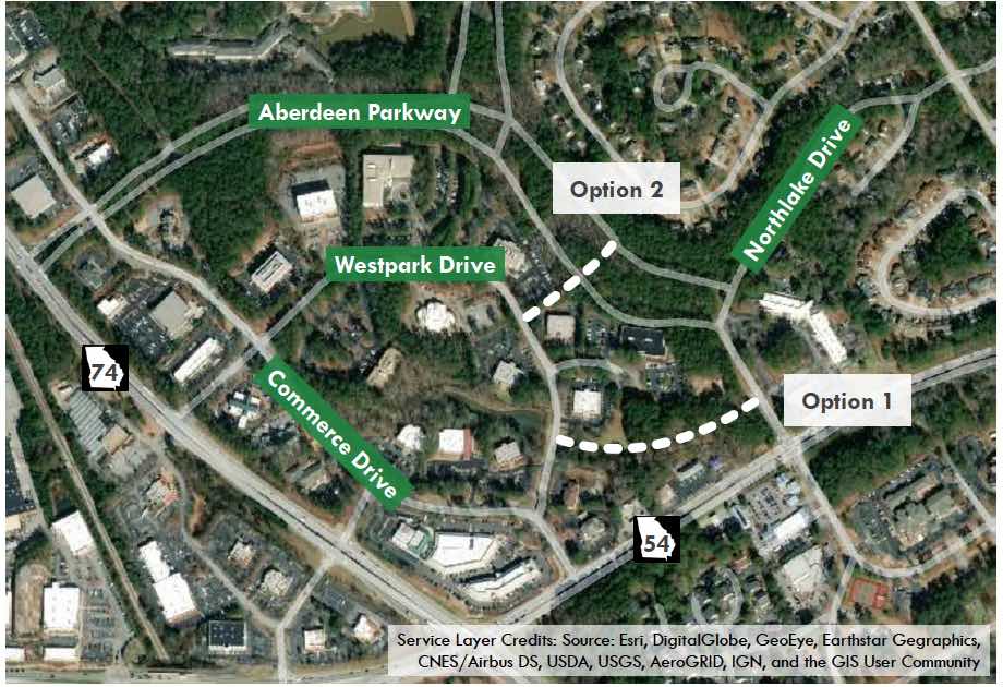
Here’s what the study said about the two new roads:
The study says, “It is recommended that the existing median opening at Commerce Drive be removed and Commerce Drive be restricted to right in/right out access at SR 54.
“Due to a lack of roadway network connectivity, closing this median opening would make it very difficult for travelers from Commerce Drive to get to SR 54 eastbound. To alleviate this concern and maintain a robust, accessible roadway network, it has been suggested that the Commerce Drive/Westpark Drive area be connected to Aberdeen Parkway and/or Northlake Drive.
“With either of these connections, trips originating in the Commerce Drive/Westpark Drive area could access SR 54 eastbound via the existing signal at Northlake Drive/Willowbend Road and SR 54.
“… preliminary field review revealed that the northern option presented challenges and was not as readily implementable as the southern option. The northern location would impact an existing parking lot, stormwater detention, and require intersections along the Aberdeen Parkway one-way pair.
“A more detailed feasibility study of the southern option — which would be built adjacent to an existing golf cart path — was conducted. An initial concept investigation was performed for a potential new road connection.
“Overall, constructing a new two-lane road connection between Westpark Drive and Northlake Drive appears feasible,” the study concludes.
The complete study is posted on the city’s website for public viewing.
Here’s the city’s summary of what’s happening:
“At the April 18 City Council Meeting, City Manager Jon Rorie gave a presentation regarding the Highway 54 Corridor beginning at Highway 74 and moving east/northeast to the city limits and slightly beyond.

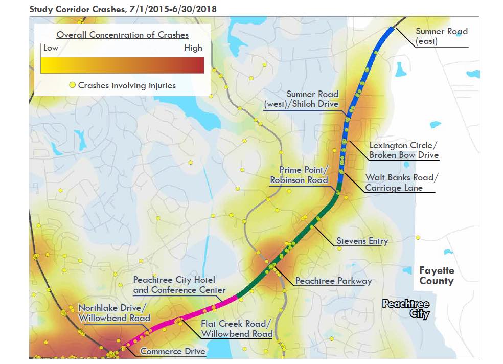
“The study analyzes traffic movements and accident data at all the intersections from Commerce Drive (Westpark) to Sumner Road East (in Unincorporated Fayette County) and makes recommendations for various intersection improvements over time to preserve mobility on the highway.
“Recommendations (listed on page 20 of the report) include
“1. Closing the median break at Hwy. 54 and Commerce Drive (Right-In/Right-Out only)
“2. Building a new road connection between Westpark and Northlake Drive
“3. Adding right turn lanes at Hwy. 54/Northlake Drive/Willowbend West Intersection.
“4. Extending left turn lanes at Hwy. 54/Northlake/Willowbend West
“5. Extend the northbound left turn lane at Hwy. 54/Northlake/Willowbend West
“6. Convert the southbound approach on Flat Creek Road to include a dedicated left turn lane and shared through & right turn lane.
“7. Widen the northbound of Willowbend Road (East at Flat Creek) to include separate left, through, and straight lanes
“8. Extend the eastbound left turn lane on Hwy. 54 at Flat Creek/Willow Road East
“9. Extend the westbound left turn lane on Hwy. 54 at Flat Creek/Willowbend Road East
“10. Convert existing median cut east of Flat Creek/Willowbend to an R-Cut and remove westbound U-Turn
“11. Consider adding northbound and southbound right turn lanes on Peachtree Parkway at Hwy. 54
“12. Convert existing intersection with Dan Lakly Drive to an R-Cut
“13. Convert existing intersection with Petrol Point to an R-Cut
“14. Consider converting existing intersection with Governors Square to an R-Cut
“15. Consider converting the intersection with Sumner Road East to an R-Cut.
“The study focused on transportation projects that address safety, capacity, and accessibility along the corridor and recommended projects to improve traffic conditions and preserve capacity.
“Ultimately, the city of Peachtree City cannot implement any of the projects on its own, and will need to coordinate with Fayette County for intersections outside the City Limits and with the GDOT, who owns and maintains the highway.
“The city had a similar study done for Hwy. 54 West in 2014, and the Highway 74 Gateway Coalition had one done last year for Highway 74 north of Highway 54,” according to the posting on the city’s website.
The firm that did the study — Pond and Company — is Alanta-metro-based with headquarters in Peachtree Corners, Ga. Its website says it has more than 500 associates in more than 20 offices in the U.S., Spain and Japan.


Leave a Comment
You must be logged in to post a comment.